The Channeled Scablands — Following the Ice Age Floods Downstream
A dam of ice broke, a lake hundreds of metres deep emptied in days, and the floods repeated dozens of times. Seven places where you can still see the evidence.
Eastern Washington is mostly gentle wheat country: rounded hills of wind-blown silt called loess. Cutting across those hills are long bands of bare black basalt, dry canyons and scattered boulders that do not belong. Together they are known as the Channeled Scablands, and they record some of the largest floods geologists have ever identified.
The easiest way to understand them is to follow the water — starting in the mountains of Montana and ending at the Pacific.
Quick facts
| Where | Eastern Washington, with flood features from Montana to Oregon |
| Source of the water | Glacial Lake Missoula, dammed by ice in northern Idaho |
| When | Near the end of the last Ice Age — roughly 18,000 to 13,000 years ago (sources differ) |
| How many floods | Dozens; one well-known count found about 40 |
| Time to drain the lake | About two days per flood (NPS estimate) |
| Area flooded | More than 41,000 km² |
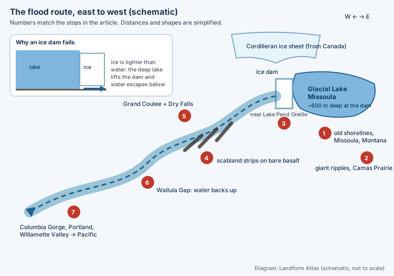 The flood route, simplified. Diagram: Landform Atlas (schematic, not to scale).
Stop 1: Lines on the hills above Missoula, Montana
On the grassy slopes of Mount Sentinel and Mount Jumbo, above the city of Missoula, you can pick out faint horizontal benches stacked one above another. Each one is an old shoreline. A lake that holds the same level for a while lets its waves notch a small terrace into the hillside. These benches show that a lake once filled the valleys of western Montana — far above today’s rooftops.
Stop 2: Ripples taller than a house at Camas Prairie
On the old lake floor in Montana lie rows of gravel ridges up to about 8 m high and roughly 30 m apart. They are giant current ripples, the oversized cousins of the ripples on a sandy stream bed. Ripples grow with water depth and speed, so ridges this size mean the lake did not trickle away. Geologist Joseph Pardee of the U.S. Geological Survey described them in 1940, and they became a key piece of evidence that the lake drained violently.
Stop 3: The ice dam near Lake Pend Oreille, Idaho
The lake existed because a lobe of the Cordilleran ice sheet slid south from Canada and blocked the Clark Fork River. Behind it the water rose to roughly 600 m deep and spread about 300 km back into the mountains.
Why did the dam fail? The leading explanation is buoyancy. Ice is less dense than water, so as the lake deepened, the dam came close to floating. Once water forced its way underneath, the dam broke up quickly. After each failure the ice advanced again, the lake refilled over decades, and the cycle repeated.
Stop 4: The scabland strips
Once released, the water spread west across the Columbia Plateau. Where it ran deepest, it stripped away the loess and soil completely and scoured the basalt underneath. Local farmers had long called these useless, rocky patches “scabland”. Seen from the air, the strips braid together like a giant river system — because that is what they were for a few days at a time. The channels even cross former drainage divides, which only water hundreds of metres deep could do.
Look closely and you will also find potholes, round pits drilled by spinning columns of water (kolks), and erratics, boulders of foreign rock that rode in on floating icebergs and dropped when the ice ran aground.
Stop 5: Grand Coulee and Dry Falls
The basalt here formed from ancient lava flows that cracked into columns as they cooled. Fast floodwater exploited those cracks, plucking out block after block. The result is the Grand Coulee, a canyon about 97 km long whose walls reach hundreds of metres in places.
Inside it stands Dry Falls: a curved cliff about 5.6 km wide and 120 m high, with lakes at its foot where the plunge pools used to be. It was a waterfall that ate its way upstream. Water pouring over the lip undermined the base, the lip collapsed, and the falls shifted north again and again, leaving the lower coulee behind as a trail. The National Park Service estimates that at its peak the flow here was around ten times that of all the world’s rivers combined today.
Stop 6: Wallula Gap, the bottleneck
All the water had to leave through one narrow notch in the hills on the Washington–Oregon border. It could not pass fast enough, so it ponded behind the gap as a temporary lake. In quiet side valleys, each flood dropped a layer of sand and silt. In 1980 Richard Waitt counted about 40 such layers in one valley wall, separated by signs of time passing — such as volcanic ash from Mount St. Helens and old animal burrows. That is the strongest evidence that the floods came many times, not once.
Stop 7: Down the Columbia to the Willamette Valley
Beyond the gap the water raced down the Columbia River Gorge and spread over the area where Portland now stands, pushing up into the Willamette Valley of Oregon. Icebergs carried rocks this far, and scientists think one of them brought the Willamette Meteorite — about 15.5 tonnes of iron — which was found in 1902 and is now in the American Museum of Natural History. (For the Clackamas people it remains a sacred object.)
The idea nobody wanted
The first person to read this landscape as flood damage was J Harlen Bretz, who started fieldwork here in 1922. Most geologists of the time insisted that landscapes change only gradually, and when Bretz presented his flood idea in Washington, D.C. in 1927, it was rejected — partly because he could not say where the water came from. Pardee’s lake answered that question. In 1965 visiting geologists wired Bretz: “We are all now catastrophists,” and in 1979 he received the Penrose Medal, the top award of the Geological Society of America.
Quick check
| Question | Answer |
|---|---|
| What held back Glacial Lake Missoula? | A lobe of ice that blocked the Clark Fork River in northern Idaho |
| Why did the ice dam fail? | Ice floats in deep water; the lake lifted the dam and water escaped beneath it |
| What does “scabland” mean? | Land where floods stripped soil down to bare basalt |
| How did Dry Falls form? | A giant waterfall that kept collapsing and retreating upstream |
| How do we know there were many floods? | About 40 flood layers, separated by ash and burrows, in southern Washington |
| Who first proposed the flood? | J Harlen Bretz, in 1923 |