Chimborazo in 10 Questions — Why Ecuador's Volcano Reaches Farther Than Everest
How can a 6,263 m volcano in Ecuador be farther from Earth's centre than Everest? Ten short answers on Chimborazo, the equatorial bulge and Andean volcanoes.
Ask which summit is “the top of the world” and most people answer Everest. Ask a surveyor and you may hear a different name: Chimborazo, an ice-covered volcano in Ecuador. Both answers are correct — they simply measure from different starting points. Here are the ten questions people ask most about it.
1. Where is Chimborazo, and how high is it?
It stands in the western range of the Ecuadorian Andes, roughly 30 km north-west of the city of Riobamba and about 1.5° south of the equator. A French–Ecuadorian GPS survey in 2016 put the summit at 6,263 m above sea level. It is the highest mountain in Ecuador — yet still about 2,600 m lower than Everest (8,849 m).
2. So in what sense is it “higher” than Everest?
Measure from the centre of the Earth instead of from sea level. The 2016 survey placed Chimborazo’s summit about 6,384.4 km from the centre. Everest’s summit is about 6,382.3 km. That makes Chimborazo’s peak roughly 2 km farther out — the point on the planet’s surface that sticks out farthest into space.
| Measured from… | Highest point | Difference |
|---|---|---|
| Sea level | Everest | about 2,600 m |
| Earth’s centre | Chimborazo | about 2 km |
3. Why does the starting point change the answer?
Because the Earth is not a perfect ball. Its radius at the equator is about 6,378 km, but only about 6,357 km at the poles — a difference of around 21 km. Geographers call this shape an oblate spheroid: a sphere slightly squashed top to bottom and widened around the middle.
A mountain that sits on the equator therefore starts from a “floor” that is already several kilometres farther from the centre. Everest, at about 28° N, stands on a part of the globe that is noticeably closer to the centre — enough to cancel its 2.6 km advantage and then some.
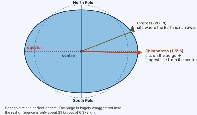 Why the summit nearest the equator reaches farthest. Diagram: Landform Atlas (not to scale).
4. What makes the Earth bulge at the equator?
Rotation. Every point on the planet completes one turn per day, but a point on the equator has the longest circle to cover — about 40,000 km — while a point near a pole barely moves. The faster a place travels round, the stronger the outward effect of the spin, so it is greatest at the equator and almost nothing at the poles.
Over very long periods, the rock inside the Earth behaves like an extremely stiff fluid and slowly adjusts to that outward effect. The Earth has been rotating since it formed, so it has always been settling into this widened-at-the-middle shape.
5. Is the Earth exactly that squashed sphere, then?
Not quite. If you trace the level that the oceans would take under gravity alone and extend it under the continents, you get a slightly lumpy surface called the geoid. Gravity is a little stronger in some regions and weaker in others, so the geoid rises and falls by roughly −107 m to +86 m compared with the smooth spheroid. Those bumps are tiny next to the 21 km bulge — the spheroid is the good approximation, the geoid the precise shape.
6. How did people find out the Earth bulges?
By measuring it in Ecuador. In the 1730s scholars disagreed: Isaac Newton’s theory said the planet should be flattened at the poles, while some French astronomers’ measurements suggested the opposite. In 1735 a French expedition — Charles-Marie de La Condamine, Pierre Bouguer and Louis Godin, joined by the Spanish officers Jorge Juan and Antonio de Ulloa — sailed for South America. Over about nine years they measured a long north–south arc of the Andes from Quito southwards. Compared with a similar survey in Lapland, their results showed that Newton was right.
While working near Chimborazo in 1738, Bouguer also tried to detect whether the mass of the mountain pulled a plumb line slightly sideways — the first attempt to measure a mountain’s gravity. Bouguer himself doubted his small result, and a cleaner version of the experiment was carried out at Schiehallion in Scotland in 1774.
A small bonus fact: Ecuador is simply the Spanish word for “equator”.
7. Why is there a giant volcano here at all?
Ecuador sits above a subduction zone. The oceanic Nazca Plate moves east and sinks beneath the South American Plate at several centimetres a year. The sinking slab carries water locked inside its minerals from its time on the sea floor. At around 100 km depth that water is released into the hot mantle rock above. Water lowers the melting point of rock, so part of the mantle melts without extra heat — geologists call this flux melting. The melt (magma) is lighter than the rock around it and works its way upward.
Because the plate sinks along the whole coast, Ecuador’s volcanoes line up in two rows running north to south, nicknamed the Avenue of the Volcanoes. Chimborazo is the tallest, close to the southern end.
8. Why is it so tall and steep?
Its magma is mostly andesite to dacite — rich in silica (around 60% or more). Silica-rich magma is thick and viscous: lava piles up near the vent instead of running far, and trapped gas can make eruptions explosive. Alternating sheets of lava and ash build a steep cone called a stratovolcano (composite volcano). Compare Hawaii, where runny basalt lava spreads into broad, gentle shield volcanoes.
Chimborazo has also rebuilt itself. Tens of thousands of years ago a large part of the older volcano collapsed in a huge debris avalanche; the city of Riobamba now stands on those deposits. Later eruptions built a younger cone, which forms today’s summit. Scientists date the collapse differently — estimates range from about 35,000 to about 60,000 years ago.
9. Could it erupt again?
It is classed as dormant, not extinct. Studies of its deposits show more than six explosive eruptions during the last 11,700 years, and the most recent one was probably around AD 550. “Dormant” means quiet for a long time, but capable of waking.
10. Was Chimborazo ever thought to be the highest mountain on Earth?
Yes. In the early 1800s many Europeans believed it was. In 1802 the naturalist Alexander von Humboldt climbed to nearly 5,900 m on its slopes — a world altitude record at the time — before a deep ravine stopped him. His sketch of how plants change with height on the mountain became one of the first diagrams of vegetation zones.
From 1808, surveys in the Himalaya showed that peaks there were far higher: first Dhaulagiri, then Kangchenjunga, and finally Everest, which was identified as the highest in 1852 and announced in 1856. The British climber Edward Whymper reached Chimborazo’s summit on 4 January 1880 with the guides Jean-Antoine and Louis Carrel.
A shrinking ice cap
Chimborazo’s glaciers feed rivers and springs used by farms and towns below. Satellite studies found that its ice area shrank by roughly a fifth between 1986 and 2013, linked to warming and changes in rainfall. Like many tropical glaciers, it is a sensitive gauge of a changing climate.
Quick check
| Question | Answer |
|---|---|
| Which mountain is highest above sea level? | Everest (about 8,849 m) |
| Which summit is farthest from Earth’s centre? | Chimborazo (about 2 km farther than Everest) |
| Why does the Earth bulge at the equator? | Its rotation pushes outward most strongly there |
| What is the geoid? | The precise, slightly lumpy shape of mean sea level under gravity |
| Which plate sinks beneath Ecuador? | The Nazca Plate |
| What kind of volcano is Chimborazo? | A stratovolcano built from silica-rich lava and ash |
| Is it extinct? | No — dormant; last eruption probably around AD 550 |
More videos on this topic
Sources
- Extremities of the Earth — Farthest Point from the Center of the Earth (Library of Congress, Maps blog)
- Chimborazo GPS survey, April 2016 — El Universo
- Samaniego et al. (2012), eruptive history of Chimborazo — IRD
- Chimborazo — Wikipedia (summarising the Smithsonian Global Volcanism Program)
- GEOID technical details — NOAA National Geodetic Survey
- French Geodesic Mission to the Equator — Wikipedia
- What was the highest mountain in the world before Everest? — Mark Horrell
- From atop an Ecuadorian peak, an epiphany about nature — Science Friday
- Detecting patterns of climate change at Volcán Chimborazo — Boise State University