How the Dolomites Formed — A Field Guide to Italy's Pale Mountains
Pale cliffs beside green meadows, towers above scree, rock that glows pink at dusk. What each Dolomites view tells you about a Triassic sea and its microbial reefs.
Stand on any pass in the Dolomites of north-eastern Italy and the same picture repeats: pale, near-vertical rock walls rising straight out of soft green slopes, with fans of broken stone at their feet. Geologists read that picture like a map of an ancient seabed. This guide works backwards — from what you can see today to the Triassic sea that made it.
Quick facts
| Where | South Tyrol, Trentino and Veneto, north-eastern Italy |
| Peaks above 3,000 m | 18 |
| Highest summit | Marmolada, 3,343 m |
| UNESCO World Heritage | since 2009, for its scenery and its geology |
| Main rock | dolomite, CaMg(CO₃)₂ |
| Age of the reef rock | mostly Triassic, roughly 250–200 million years old |
View 1: Pale cliffs next to green meadows
This contrast is the key to the whole range. The pale walls are the remains of carbonate platforms — flat-topped piles of reef rock that grew in shallow, sunlit water. The green, gently sloping ground between them sits on what used to be deep basins, later filled with mud, clay and dark volcanic material.
Hard rock and soft rock wear down at very different speeds. Clay-rich basin rock crumbles and slides once it is soaked; compact dolomite resists for far longer. So erosion strips the soft rock into rolling pasture and leaves the old platforms standing as cliffs — some more than 1,500 m high.
The textbook example is Seiser Alm (Alpe di Siusi), often described as Europe’s largest high-altitude meadow, which spreads right up to the sheer walls of the Sciliar (Schlern).
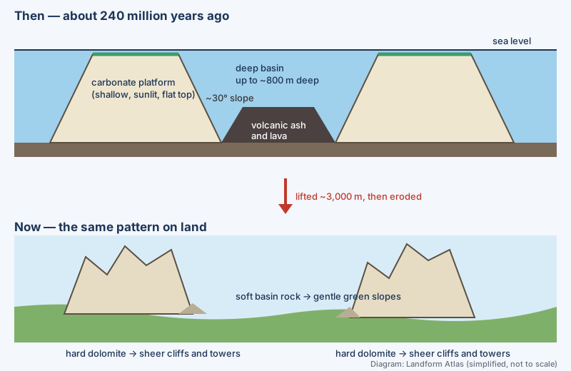 The platform–basin pattern then and now. Diagram: Landform Atlas (simplified, not to scale).
View 2: Why the platforms were there in the first place
During the Middle Triassic, around 245–235 million years ago, this region lay near the western end of the Tethys, a tropical ocean that cut deep into the supercontinent Pangaea. The Earth’s crust here was being pulled apart. Stretched crust thins, breaks into blocks along faults and subsides — but not evenly.
- On blocks that sank slowly, the sea floor stayed shallow enough for light-loving reef builders. They kept adding rock as the ground subsided, building platforms hundreds of metres thick.
- On blocks that sank fast, water became too deep and dark; these turned into basins, in places up to about 800 m deep.
The Latemar near Lake Carezza is one of the best preserved: around 242 million years ago it was a roughly circular platform 6–8 km across, and its flanks still dip at close to 30°, the original angle of the reef slope.
View 3: Reefs without many corals
Look closely at Dolomites reef rock and you will find few big coral skeletons. The platforms grew in the aftermath of the end-Permian mass extinction (about 252 million years ago), when vast eruptions in today’s Siberia warmed the planet and stripped oxygen from the oceans. Most marine species vanished, and reef ecosystems disappeared for millions of years.
The recovery was led by tough survivors. Studies of the Latemar estimate that roughly 40% of the platform was built by microbial communities, and about a third by mineral cement — calcium carbonate that crystallised directly from seawater inside the reef. Sponges, algae and corals played a smaller role. Corals became more important later: by about 230 million years ago, some Dolomites corals already hosted symbiotic algae, as modern reef corals do.
View 4: Dark layers between the platforms
Around 240 million years ago, volcanoes erupted across the region for at least five million years. Ash, lava and broken volcanic debris poured into the basins; near the Sciliar these deposits are more than 500 m thick. Blocks of reef rock that broke off platform edges during the eruptions are found buried inside them. When the eruptions stopped, new and larger platforms grew over the filled basins — the almost circular Sella group is the classic example.
View 5: Rock that barely fizzes
A drop of dilute acid makes limestone (calcium carbonate) fizz. Dolomite reacts only weakly, because half of its calcium is replaced by magnesium, arranged in alternating layers inside each crystal. The French geologist Déodat de Dolomieu described this odd rock from the Tyrol in 1791, and it was named dolomite after him. The mountains took the name later — partly through the 1864 travel book The Dolomite Mountains by Josiah Gilbert and George Churchill; older names included Monti Pallidi, the “Pale Mountains”.
The reefs were not built as dolomite. They were limestone first, and magnesium-rich water later converted much of it — a process called dolomitization. In the Latemar, chemical evidence points to warm seawater circulating through the platform, heated by nearby magma. Why dolomite is so hard to grow had long puzzled scientists; a 2023 study from the University of Michigan and Hokkaido University showed that repeated dissolving and re-wetting removes defects that otherwise stall crystal growth.
View 6: Sea floor at 3,000 metres
The platforms rose with the Alps. As Africa moved north and the Tethys closed, the Adriatic plate pushed into Europe. The Dolomites block was lifted largely in one piece, along major faults such as the Valsugana fault, with much of the uplift happening in the last ~20 million years. Because the block was not crumpled into tight folds, the original platform-and-basin layout survived — which is why UNESCO describes these platforms as “fossilized atolls”.
View 7: Towers, needles and fans of scree
Uplift cracked the brittle dolomite along near-vertical joints. Water seeps into the cracks and expands as it freezes, prising blocks loose winter after winter; Ice Age glaciers deepened the valleys and plucked rock from the base of the walls. The result is a skyline of towers and spires, each standing above a pale apron of scree. Rockfalls still happen, so the landscape is changing even now.
Not every summit began as a reef: the Tre Cime di Lavaredo are carved from slightly younger dolomite (the Dolomia Principale) that formed on wide tidal flats.
View 8: The pink glow at dusk
At sunrise and sunset, sunlight crosses more atmosphere; blue light is scattered away and the remaining red and orange light tints the pale rock. Locals call it enrosadira. A Ladin legend explains it differently — as King Laurin’s hidden rose garden, cursed to vanish by day and by night but not in the moments in between.
Quick check
| Question | Answer |
|---|---|
| What are the pale cliffs made of? | Dolomite — Triassic platform rock |
| Why are the meadows next to them so gentle? | They lie on soft, clay-rich basin and volcanic rock |
| Who mainly built the early Triassic reefs? | Microbial communities, plus mineral cement |
| How deep were the basins? | Up to about 800 m |
| Why does dolomite barely fizz in acid? | Its crystals contain magnesium as well as calcium |
| What lifted the region? | The Adriatic plate pushing into Europe as the Alps formed |
| Where does the name come from? | Déodat de Dolomieu, who described the rock in 1791 |
More videos on this topic
Sources
- The Dolomites — UNESCO World Heritage Centre (site 1237)
- Dolomites — Wikipedia
- Latemar — Wikipedia
- Déodat Gratet de Dolomieu — Wikipedia
- Dolomite (mineral) — Wikipedia
- 200-year-old geology mystery resolved — University of Michigan News (2023)
- Frankowiak, Roniewicz & Stolarski (2021), photosymbiosis in Triassic corals — PeerJ 9:e11062
- Permian–Triassic extinction event — Wikipedia
- Seiser Alm — Wikipedia
- Tre Cime di Lavaredo — Wikipedia
- Alpenglow — Wikipedia